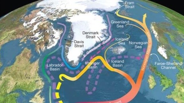
Nordic Seas and subpolar basins with surface currents (solid curves) and deep currents (dashed curves) that form part of the Atlantic meridional overturning circulation (R. Curry / Woods Hole)
PUBLISHED JUL 30, 2023 10:54 PM BY THE CONVERSATION
Amid news of lethal heatwaves across the Northern Hemisphere comes the daunting prospect of a climate disaster on an altogether grander scale. New findings published in Nature Communications suggest the Atlantic meridional overturning circulation, or Amoc, could collapse within the next few decades – maybe even within the next few years – driving European weather to even greater extremes.
The Amoc amounts to a system of currents in the Atlantic that bring warm water northwards where it then cools and sinks. It is a key reason why Europe’s climate has been stable for thousands of years, even if it’s hard to recognise this chaotic summer as part of that stability.
There is much uncertainty in these latest predictions and some scientists are less convinced a collapse is imminent. Amoc is also only one part of the wider Gulf Stream system, much of which is driven by winds that will continue to blow even if the Amoc collapses. So part of the Gulf Stream will survive an Amoc collapse.
But I have studied the links between Atlantic currents and the climate for decades now, and know that an Amoc collapse would still lead to even greater climate chaos across Europe and beyond. At minimum, it is a risk worth being aware of.
Amoc helps keep Europe warm and stable
To appreciate how much Amoc influences the climate in the northeast Atlantic, consider how much warmer north Europeans feel compared to people at similar latitudes elsewhere. The following maps show how surface air temperatures depart from the average at each latitude and highlight patterns of warm and cool spots around the planet:
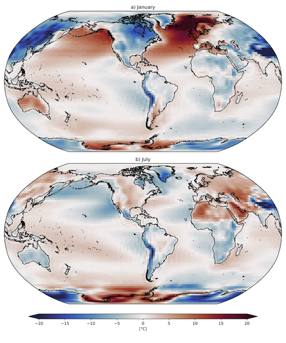
Surface air temperature departure from 1948-2018 zonal average in January (top) and July (bottom). Marsh & van Sebille, 2021; Data: NCEP/NCAR, Author provided
Most striking in the northern winter (January) is a red spot centred to the west of Norway where temperatures are 20°C warmer than the latitude average, thanks to Amoc. The northeast Pacific – and therefore western Canada and Alaska – enjoys a more modest 10°C warming from a similar current, while prevailing westerly winds mean the northwest Atlantic and northwest Pacific are much colder, as are the adjacent land masses of eastern Canada and Siberia.
The weather and climate of Europe, and northern Europe in particular, is highly variable from day to day, week to week and year to year, with competing air masses (warm and moist, cold and dry, and so on) gaining or losing influence, often guided by the high-altitude jet stream. Changes in weather and climate can be triggered by events located far away – and over the ocean.
How ocean temperatures are linked to weather
Over recent years Europe has witnessed some particularly unusual weather, in both winter and summer. At the same time, peculiar patterns of sea surface temperatures have appeared across the North Atlantic. Across great swathes of the ocean from the tropics to the Arctic, temperatures have persisted 1°C-2°C above or below normal levels, for months or even years on end. These patterns appear to exert a strong influence on the atmosphere, even influencing the path and strength of the jet stream.
To an extent, we can attribute some of these sea surface temperature patterns to a changing Amoc, but it’s often not that straightforward. Nevertheless, the association of extreme seasons and weather with unusual sea temperatures might give us an idea of how a collapsed Amoc would unsettle the status quo. Here are three examples.
Northern Europe experienced successive severe winters in 2009/10 and 2010/11, subsequently attributed to a brief slowdown of the Amoc. At the same time heat had built up in the tropics, fuelling an unusually active June-November hurricane season in 2010.
In the mid 2010s a “cold blob” formed in the North Atlantic, reaching its most extreme in the summer of 2015 when it coincided with heatwaves in central Europe and was one of the only parts of the world cooler than its long-term average.
The cold blob looked suspiciously like the fingerprint of a weakened Amoc, but colleagues and I subsequently attributed this transient episode to more local atmospheric influences.
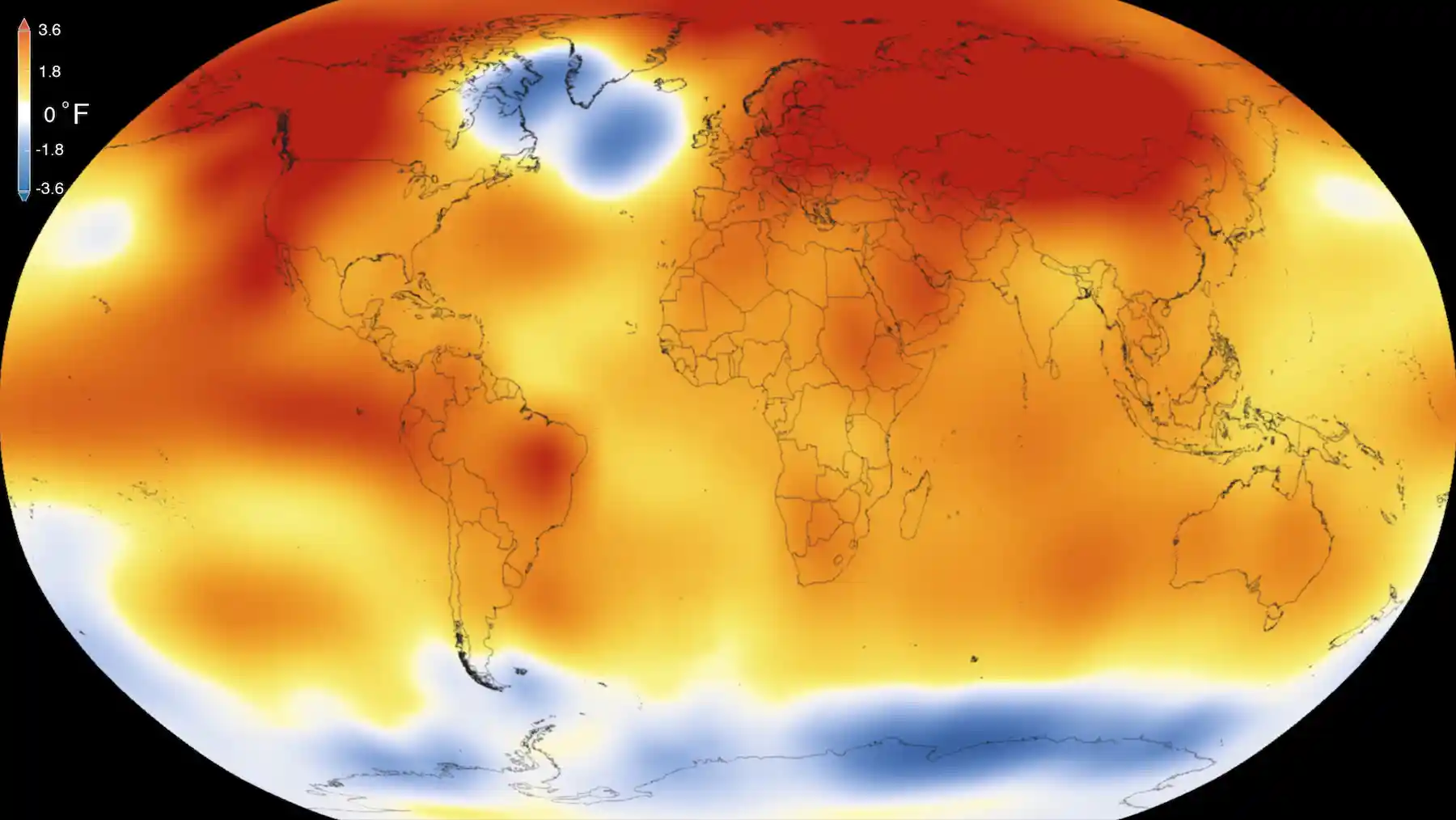
Spot the blob: temperatures in 2015 – at the time, the warmest year on record – compared to long-term averages. NASA/NOAA
In 2017, the tropical Atlantic was again warmer than average and once again an unusually active hurricane season ensued, although the Amoc was not as clearly involved as 2010. Extensive warmth to the northeast in late 2017 may have sustained hurricane Ophelia, emerging around the Azores and making landfall in Ireland in October.
Based on just these few examples, we can expect that a more substantial reorganisation of North Atlantic surface temperatures will have profound consequences for the climate in Europe and beyond.
Larger ocean temperature extremes may alter the character of weather systems that are powered by heat and moisture from the sea – when and where temperatures rise beyond current extremes, Atlantic storms may grow more destructive. More extreme ocean temperature patterns may exert further influences on tropical hurricane tracks and the jet stream, sending storms to ever more unlikely destinations.
If the Amoc collapses we can expect larger extremes of heat, cold, drought and flooding, a range of “surprises” to exacerbate the current climate emergency. The potential climate impacts – on Europe in particular – should add urgency to our decision-making.
Robert Marsh is a Professor of Oceanography and Climate at the University of Southampton.
This article appears courtesy of The Conversation and may be found in its original form here.